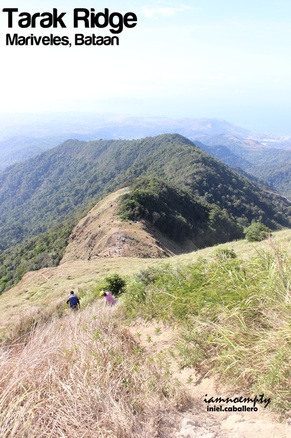
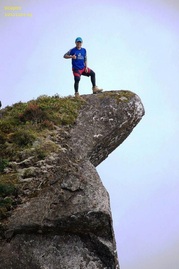
It was during the Habagat incident of 2012 when I had my first attempt to reach the well known Tarak Ridge in Bataan. Continuous rain for 2 days hindered us from reaching the summit and Papaya River was then our playground for 2 days. A "revenge" climb was then planned however it did not materialized. 9 months after, this ridge became my first training climb activity in preparation for Mt. Mantalingajan Traverse. Tarak was not part of the list of possible training climbs however it topped out the options I had when I learned that this ridge can be traversed. So I took a bus routed to Alas Asin, Batangas thinking that in case I cannot find any Guide (only few guides knew the traverse trail) I will proceed via the traditional trail.  Fast paced bus ride, I arrived at Alas Asin Brgy. Hall around 02:45am. I was lucky that time because the brgy. official on duty was able to secure a guide that knows the traverse trail and was still up at wee hours. My guide, Bernie, a 41 yrs old active runner/marathoner, I expected a fast paced traversed awaits. To add a little spice for this activity, I requested if we could do a Reverse-Traverse instead. He was hesitant at first however agreed and gave a heads up that the reverse will surely be a challenge. At 03.45 am we started hiking, familiar trail was way ahead until we reached a fork, leading to Nanay Cording's place while the other one was leading to the forest. Bernie chose the latter part to avoid paying (or forced donation as he described it) to Nanay Cording. Having a gradual to a manageable slope was one advantage this trail can offer, bypassing the slope terrain going to an open field before entering the trail going to Papaya River. 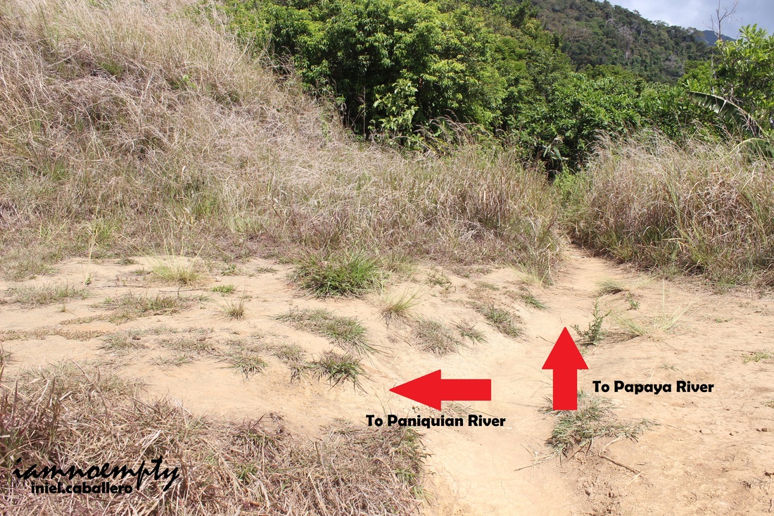 The traverse starts from the left side of a fork in an open field (right side leads to the forested area going to Papaya River). This trail will lead hikers to Paniquian River, first 10 minutes was a riot between me and Cogon grass taller than human. Though it was too dark that time and the only source of light we had was my headlamp (Mang Bernie was using the flashlight feature of his phone, sometimes he turns it off to save battery I guess) I was assuming we were inside a forested area cause I could not find even a single star above.  Most of the time we were descending on a "walk in single file" type of trail with loose soil and cliff on the side. Around 4:20am when we started hearing water rushing from below, it was our indicator that Paniquian river was just meters ahead. It was 4:32am when we reached the river and took a 5 minute break. Way ahead was the Paniquian Falls however before reaching the said Falls, battling against these boulders slowed us down. Though the sun was beginning to shed light, it was not enough to guide us, the boulders were slippery and loose. Some boulders had markings on it, not to worry, these were carved or scratched arrows pointing to the right directions, though I am against it since its another form of vandalism. 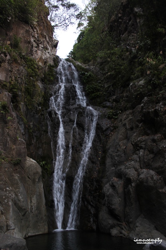 We took another 5 minutes break by the time we reached the falls. The current was not that strong as I was expecting since it was summer season but it was beautiful enough. After appreciating the beauty, the worst part came next. It was an hour and thirty-three minutes of full assault. The assault started at the opposite side of the river, we scrambled all the way up holding onto rocks, branches or roots. When we gain access the top most portion, Mang Bernie pointed something ahead, it was the upper portion of the Falls. We crossed the above river and scaled another full assault trail, it was the trail going all the way to Tarak Summit. The first part of the assault would be something like the trail from Station 3 to Station 7 (Sipit and Palanggana Trail meets) of Mt. Makiling. In Makiling, ropes were installed to assist hikers however on this trail we relied on small branches, rocks or roots. Just above another fork which leads you either to the summit or deeper into the forest. 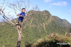 Mt. Mariveles Mt. Mariveles The trail leading to summit was the second half of the the entire full assault. Few fallen trees blocked the trail, either you hopped over it or crawl under to pass through. An open assault trail welcomed us while to the right side, the towering Mt. Mariveles was sighted. Scrambling on this rocks piled as if it were platforms or view deck, a spot for photo ops with Mt. Mariveles as the background. We heard giggles and laughter, voices of happy hikers successfully submitted Tarak Ridge few meters away from us. The summit was not that wide though however it offers a closer view of Mt. Mariveles. We waited until the hikers left before I had my solo shot at the dead tree standing at cliff. I took some time to enjoy the summit and let the moment sinked in. We covered the traverse side for about 4hours and 30 mins, it was fast according to Mang Bernie. Few more hikers were heading to our direction when we decided to start our descend. From above, the first thing I noticed was the island from a far. That familiar shape my mind was trying to remember, "that's Corregidor" Mang Bernie shouted. The ridge was occupied by hikers who had spent overnight. Some were heading to the summit thus creating traffic, others were busy cleaning up while some just woke up. 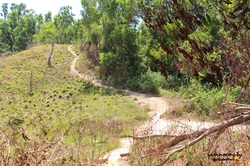 Mang Bernie advised me to move faster since more hikers were heading to the summit and more coming from Papaya river will follow and will surely create traffic. The trail from ridge going to Papaya River was a full descent. We maneuvered accordingly, as the trail was on its worst condition. I was some what disappointed after seeing Papaya river, as if it was not a river... it was more like a stream. Mang Ben went further above just to get enough water. 9months ago was way different from that time. As we moved along, the trail was then so familiar. It was so hot that time, even though we were hiking inside the forested area. Mang Bernie pointed the traditional trail (the descend) while we chose the easy part then we were back to the fork were Paniquian trail and Trad trail meets. By 10.45am we completed the entire traverse. Mang Bernie gave me a thumbs up for traversing the entire climb within 7 hours and 30 mins thus according to him some opted to traverse Tarak and only a few chose to traverse it like what we did that day. My Personal Itinerary 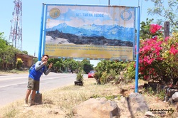 12:00am Depart Manila (Cubao) via Bataan Transit 02:45am Arrived/Registered at Brgy. Alas Asin, Bataan. Secured Guide 03:15am Start Trek via Reverse Traverse Trail 04:32am Fork, Paniquian and Trad Trail 05:26am Paniquian River 05:50am Paniquian Falls, scout for the trail going to summit. 06:12am Start ascent 07:45am Summit reached, chat with fellow hikers, PhotoOps (hintayan kasi daming hiker nasa summit) 08:15am Descend 08:25am Ridge (Traffic) - Hindi ko na nanote anong oras nakadating sa Papaya River 10:45am Accomplished Reverse Traverse Dayhike
6 Comments
jm
5/29/2013 07:52:17 pm
May number ka b ng guide? At magkano ang pa guide? Thanks 5/29/2013 08:11:09 pm
091291220499 - Bernie
Jm
5/30/2013 07:17:29 pm
thanks sir..
Jm
5/30/2013 07:21:15 pm
sir,,parang sobra ng isang number?
Tin Calud
5/12/2015 01:55:35 pm
Kung wala kaming guide maliligaw kaya kami sa trail na dinaanan mu papunta sa ridge. Mukhang di mu napuntahan ung el saco peak.. Leave a Reply. |
This is my blog...
My Diary..... Travel... Climb... Swim..... My Adventures in Words Archive
February 2016
Mountains
All
Social Media Activities Instagram: @iamnoempty

Travel & Leisure |